
The current blog entry is below, to read previous entries, go to: 2021 Archive, 2022 Archive, 2023 Archive, 2024 Archive, 2025 Archive, or 2026 Archive.
January 5, 2026
News and notes

Lightly falling snow on Crescent Lake, January 1, 2026
This week, before going on to discuss the geology and mineral resources of Morocco, we will first look at some news items I thought were interesting. The picture above is from Crescent Lake on January 1.
If you enjoy my blogs, bookmark the site and check on Mondays rather than relying on social media postings which can get lost in the shuffle. For my news items, I try to stick to open access papers.
Comments
If anyone has comments on any of my postings, please leave a comment on the Linkedin page for the posting or email me at raymondreichelt@gmail.com.
Geopolitics
There are lots of news reports on the American action in Venezuela.
Meanwhile: Inside US Plans To Reopen WWII Air Bases for War With China.
Geopolitical analysis from Alexander Dugin.
Research and News
Planetary Geology: Photochemistry of Fe (II) and carbonate-bearing waters and the influence on Greenhouse Gas production in Early Mars.
Playing with rocks in the lab: Experimental Deformation of Textured Amphibolites in the Semi-Brittle Regime: Microstructural Signatures of Dislocation-Mediated Deformation.
Eclogite-facies metamorphism of continental crust at the Mesoarchean-to-Neoarchean transition.
Plate Tectonics
Neotectonic Origins for the Meadow Bank Scarp, Wabash Valley Seismic Zone, USA .
Ancient, buoyant mantle under the Sierra Leone Ridge in the equatorial Atlantic.
Paleontology
Ancient African bedrock reveals the violent beginnings of life on our blue planet.
Ammonite survival across the Cretaceous–Paleogene boundary confirmed by new data from Denmark.
Rewind evolution and get a different result, The variability of evolvability: Properties of dynamic fitness landscapes determine how phenotypic variability evolves; Science Daily summary here.
Ore Deposit Geology
Complex carbonate ore mineralogy in the Mountain Pass carbonatite rare earth element deposit, U.S.A.
3D Multi-Layer Geological Modeling of the Allou Kagne Attapulgite Deposit (Senegal, West Africa).
Mining and Energy
Bad boys: Ganfeng Lithium says it may face insider-trading charges; cue the music.
Africa’s Emerging LNG Corridor Is Taking Shape South Of The Sahara.
Coal Remains King in India While Exports Optimize Domestic Stock.
Ivanhoe Mines begins copper anode production at new Congo smelter.
Platinum price set for biggest monthly gain in 39 years on EU auto policy boost.
Vaca Muerta Shale: Argentina’s Shale Boom Propels It Past Colombia in Oil Output.
Commodity and Financial Market Linkages: Granger Causality Insights from Rare Earths, Crude Oil, and Equities; Rare Earth Exchanges summary here.
Environmental Geology and Hydrogeology
NGWA Submits Comments on Coal Combustion Residuals Disposal Extension.
Whiskey’s for drinking, water’s for fighting over:
Hungary’s ‘water guardian’ farmers fight back against desertification.
‘There’s no water any more’: How palm oil plantations drained a Guatemalan rainforest community.
Volcanoes, Earthquakes and Geohazards

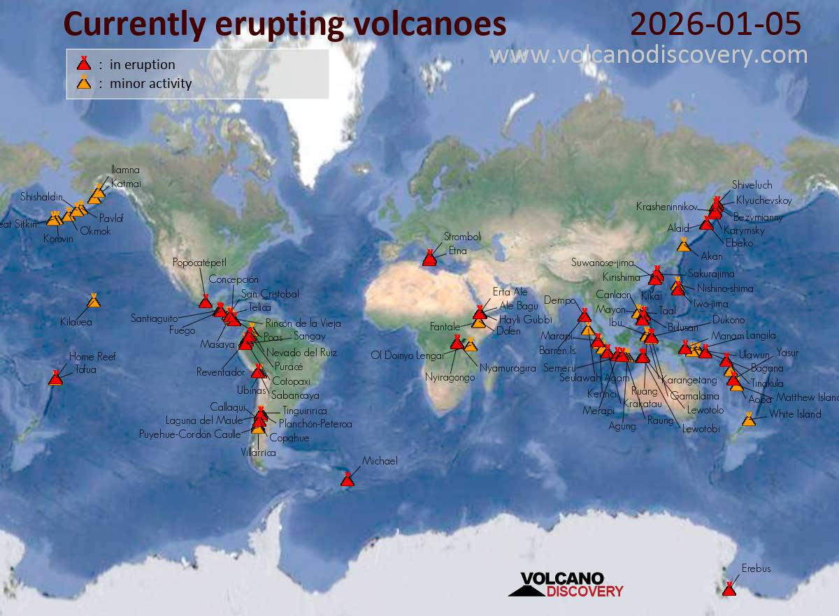
Volcanoes
United States Geological Survey (USGS) Volcano Observatories:
Yellowstone Caldera Chronicles: The top Yellowstone geological stories of 2025.
Volcano Watch – Hauʻoli Makahiki Hou: a round-up of fireworks from Kīlauea's fountains.
Deciphering chemical complexity in monogenetic eruptions: Xitle Volcano, Mexico.
Video: The Golden Volcanic Glass Only Formed from 1,000+ Ft Lava Fountains.
What's inside Mexico's Popocatépetl? Scientists obtain first 3D images of the whole volcano.
Earthquakes
M6.5 subduction earthquake strikes near Acapulco, Mexico; USGS summary here.
Rapid Characterization of the 2025 Mw 8.8 Kamchatka, Russia Earthquake.
Seismic hazard analysis: Improving High‐Frequency Spectral Estimates in Spectral Ratio Analysis Using Between‐Event PGA Differences.
Mantle Earthquakes: Deep Quakes Beneath the Moho in the Wyoming Craton
Free Geology Books and Other Stuff
Free geology books can be downloaded from these sites:
OreZone Readers and Experts Telegram Channel; the Ore Zone channel also shows employment opportunities for geologists.
The Groundwater Projecthas many groundwater geology books for free downloadtogether with free online courses, listed here.
Free Groundwater Modeling Courses from the HydroGeoCenter.
From Western Australia: Carbonatite, lamprophyre and host rocks in the northern Aileron Province.
Brett Davis’ book on veins in a deforming rock mass: “The Veining Bible”; also at this site.
From the Mineralogical Society of America: Handbook of Mineralogy.
Upcoming Events
January 5, 2026
Geology and Mineral Resources – Morocco
Introduction
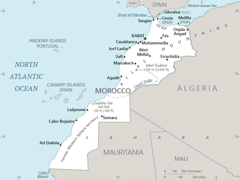
Figure 1a – Morocco
Credit:
CIA
World Factbook, public
domain
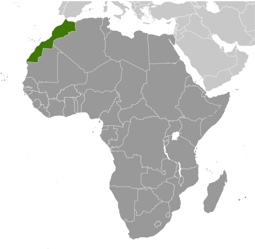
Figure 1b – Location
of Morocco
Credit:
CIA
World Factbook, public
domain
The Kingdom of Morocco is a country of 37,387,585 people in the Maghreb region of North Africa. The country has a total area of 716,550 square kilometres (km2) of which 270,000 km2 is the Western Sahara occupied by Morocco since 1975 and the remaining 446,550 km2 is Morocco proper. Morocco has coastlines on the Mediterranean Sea, to the north, and the Atlantic Ocean, to the west. Morocco’s land borders are with Algeria, to the east, and Mauritania, to the south. Morocco’s occupation of the Western Sahara is still in dispute. Also in dispute are Morocco’s claim to the the Spanish exclaves of Ceuta, Melilla and Peñón de Vélez de la Gomera, and several small Spanish-controlled islands off its coast. These disputes are a function of the complicated history of Morocco and especially the French and Spanish “protectorates” established during the 20th Century.
Moroccans are moderately well off with a modest per capita GDP (PPP) of $11,270 and a high Human Development Index of 0.710. The major industries of Morocco are: automotive parts, phosphate mining and processing, aerospace, food processing, leather goods, textiles, construction, energy, tourism. The main trading partners are: China, France, Germany, Italy, Spain, the United Kingdom, and the United States with Spain leading in imports and exports.
For more details on the country, check out the CIA World Factbook on Morocco as well as the Wikipedia article.
Geology

Figure 2 – Tectonic Map
of Northwest Africa
Credit:
Figure 1.11 in Michard et al, 2008
The geology of Morocco reveals a complex geological history. Morocco sits on the West African Craton and its current form is result of a succession of orogenies.
The oldest rocks in Morocco are Archean in age and include the rocks of the of the Reguibat Shield. The Reguibat Shield also includes the next oldest rocks in Morocco, those of the Proterozoic aged Eburnian formations. Also Proterozoic in age are the rocks formed during the Pan-African Orogeny which extended from the Neoproterozoic into the Early Paleozoic eras.
Next oldest are the rocks formed during the Caledonian and Variscan orogenies during the Paleozoic Era. During these orogenies, the land that is now Morocco was pushed up against what is now North America into the supercontinent of Pangea. The Atlas Mountains in Morocco formed as the result of the Caledonian and Variscan orogenies.
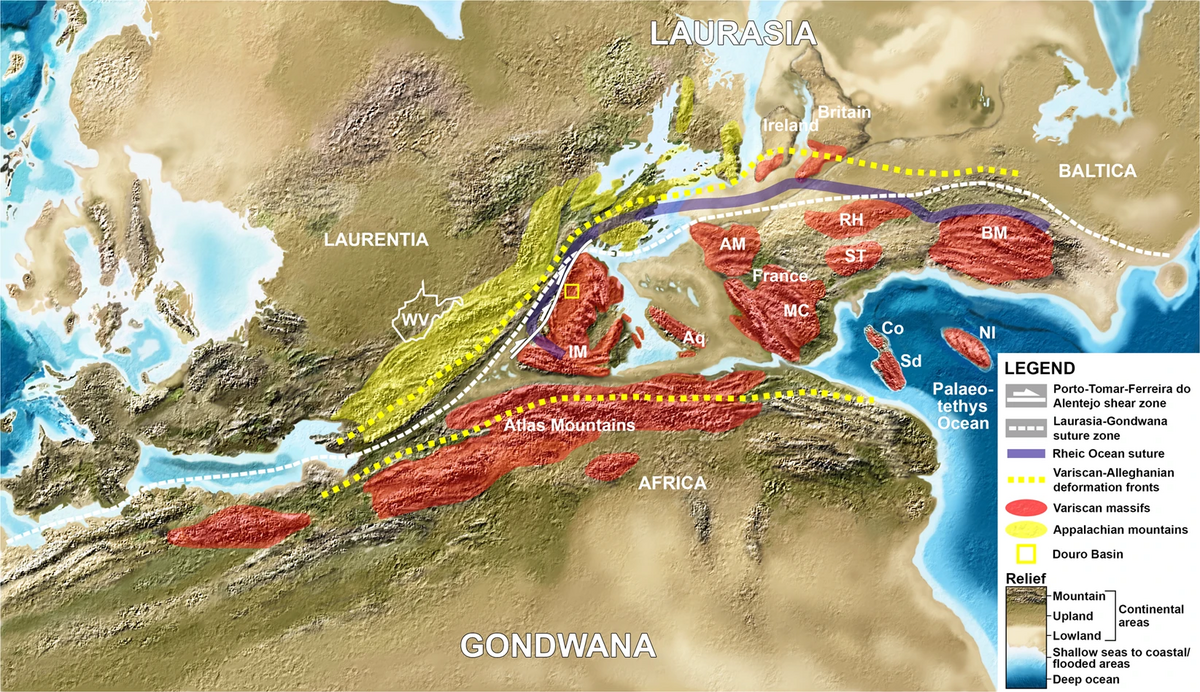
Figure 3 – Trans-Pangaea
Mountains
Credit:
Figure 5 in Correia
& Murphy, 2020.
Creative
Commons Attribution
4.0 International license
The breakup of Pangea began during the Permian Period and continued into the Mesozoic Era, leading to the creation of the Atlantic Ocean. The final orogeny affecting Morocco is the Alpine Orogeny, where Africa is moving northward into Eurasia, this orogeny began in the Late Mesozoic and continues to this day.
Figure 4, below, shows a more detailed geologic map of Morocco.

Figure 4 - Geological map
of Morocco
Credit:
Figure 02 in Charton
et al, 2020, Creative
Commons Attribution
4.0 International license
So what kinds of rocks are found among the various aged formations in Morocco? Starting with the suite of Precambrian deposits, the Archean rocks of Morocco are predominantly supracrustal rocks and include gneiss, granite, metagabbro, serpentinite, quartzite, chert, and impure marble. The Paleoproterozoic rocks of the Kerdous, Bas Drâa, Tagragra and Zenaga regions in the Anti-Atlas Mountains include schist, migmatite, and granitic intrusions. The Neoproterozoic rocks in Morocco include high-grade metamorphic rocks, granitic intrusions, and mafic to ultramafic dykes in the nappes of the Adrar Souttouf Massif. Other Neoproterozoic rocks in Morocco include ophiolites, parts of oceanic crust that are now exposed.
Paleozoic aged (Cambrian to Permian periods) in the High Atlas Mountains and Meseta include metamorphosed tillite, arenite, schist, limestone, sandstone, and granite. The Cambrian to Carboniferous aged rocks of the Anti-Atlas Mountains are mostly the result of shallow marine sedimentation and includes tillite, arenite, schist, limestone and sandstone. The Ordovician to Carboniferous aged units of the Dhlou, Zemmour, and Tindouf basins include tillite, arenite, shale, and limestone.
The Triassic aged rocks of the High and Middle Atlas Mountains are siltstone, sandstone, and evaporite together with some basalt related to the rifting the of the Atlantic Ocean. The Jurassic aged rocks in the Atlas Mountains are predominately carbonate platform rocks, often forming karst topography. Late Jurassic to Early Cretaceous deposits in the Atlas Mountains include red-bed sandstone, marine marl, and fluvial conglomeratic calcarenite.
The Early Cretaceous deposits of the Rif Belt of northern Morocco is made up of flysch, associated with tectonic activity including the opening of the Atlantic Ocean. The Rif also includes Cretaceous, Paleogene, and Neogene aged limestone as well as older ophiolites and metamorphic basement.
Along the Atlantic coast, the Tarfaya-Dakhla Basin is made up of Cretaceous to Neogene aged sediments including marine to lagoonal sediments with organic-rich black shales and sandy marls. Other basins include the Phosphate Plateau north of Marrakesh, made up of limestone, marl, and (as you might guess) phosphorite. There are also Paleogene, and Neogene aged calcareous lacustrine deposits in northeastern Morocco.
The youngest deposits in Morocco are Paleogene to Quaternary aged including alluvial and coastal sand deposits; sand dunes in the deserts; the Souss Basin near Agadir; and the Saïs Basin from Rabat to Fez.
Mineral Resources

Figure 5 – Barite Sample
from Jebel
Ouichane
Credit:
Lech
Darski, Creative
Commons Attribution
4.0 International license
According to the USGS Minerals Yearbook for Morocco, the country’s mineral industry includes the production of metallic minerals, industrial minerals and a modest amount of fuel minerals, including:
Arsenic trioxide from the hydro-metallurgy complex at Managem.
Barite from artisanal producers in the Draa-Tafilalet Region as well from at least 10 industrial mines including those run by ADO Barite Morocco and SMBM - Minière des Barites et Minéraux.
Cement, lime, and pozzolan for construction is produced at numerous locations.
Bentonite and montmorillonite clay is mined at six mines.
Cobalt is mined at the Bou-Azzer Mine.
Copper is mined at the Ousdiden copper deposit, the AKA mine, the Ouansimi Copper Mine, the Bleida Mine, the Bouskour Mine, the Oumjrane Mine, and the Douar Hajar Mine.
Fluorspar is mined at a mine in Taourirt Province at a facility owned by Gujarat Fluorochemicals Limited.
Gold is mined in the Guemassa Massif at a facility operated by Managem Group.
Iron ore is mined at the Mines Del Rif Nador Mine.
Lead is mined by artisanal miners as well as a mines at Fez - Boulemane, Marrakech - Tensift - Al Haouz, Meknes - Tafilalet, and Oriental.
Manganese is mined at the IMINI mine in Ouarzazate.
Natural gas is produced at the Sebou and Oulad N’Zala Field and is supposed to begin soon at the Tendrara field. Gas condensate is also produced at the Sebou field.
Phosphate rock is mined at Khouribga, Ganntour, the Youssofia Mine, and the Boucraa Mine.
Salt is produced from brine at Lake Zima and rock salt is mined at Ain Tekki.
Silver, lead and zinc is produced at the Tighza Mining Center and the Guemassa Mine; silver and copper at the Tirzet Mine; and gold and silver at the Zgounder Mine.
Pyrophyllite is produced at a mine near Khenifra; talc is mined near Tinjdad and Taliouine.
Zinc is produced by artisanal miners from mines at Errachidia, Figuig, and Tafilate in the Draa-Tafilalet Region.
The latest mineral production statistics from the USGS can be found here. Figure 6 links to an interactive mineral occurrence map of Morocco from Mindat.org.
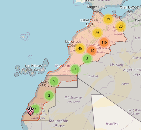
Figure 6 – Interactive
Mineral Occurrence Map of Morocco,
Credit:
Mindat.org
Summary

Figure 7 – Sunset over
Jamaa El Fna, Morocco
Credit:
MoroccanPixels, Creative
Commons Attribution
4.0 International license
Morocco has been a favourite tourist destination for a long time, so if you go, take the usual precautions ahead of time, For geologists, the complex geology of Morocco suggests that it is a promising place for mineral exploration. It helps that the government is relatively stable. As well as the on shore prospects in a variety of metallic and industrial minerals, there may be opportunities for off shore oil and gas development in the future.
Standard Caveat
J. Robert Oppenheimer on freedom and scientific inquiry
The purpose of my weblog postings is to spark people's curiosity in geology. Don't entirely believe me until you've done your own research and checked the evidence. If I have sparked your curiosity in the subject of this posting, follow up with some of the links provided here. If you want to, go out into the field and examine some rocks on your own with the help of a good field guide. Follow the evidence and make up your own mind.
In science, the only authority is the evidence.